
Page 10 - link magazine
P. 10
The Link Magazine. May 1996
10
Looking at the plans
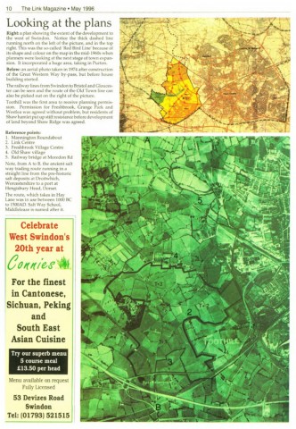
Right: a plan showing the extent of the development to
the west of Swindon. Notice the thick dashed line
running north on the left of the picture, and in the top
right. This was the so-called 'Red Bird Line' because of
its shape and colour on the map in the mid-1960s when
planners were looking at the next stage of town expan-
sion. It incorporated a huge area, taking in Purton.
Below: an aerial photo taken in 1974 after construction
of the Great Western Way by-pass, but before house
building started.
The railway lines from Swindon to Bristol and Glouces-
ter can be seen and the route of the Old Town line can
also be picked out on the right of the picture.
Toothill was the first area to receive planning permis-
sion. Permission for Freshbrook, Grange Park and
Westlea was agreed without problem, but residents of
Shaw hamlet put up stiff resistance before development
of land beyond Shaw Ridge was agreed.
Reference points:
1. Mannington Roundabout
2. Link Centre
3. Freshbrook Village Centre
4. Old Shaw village
5. Railway bridge at Moredon Rd
Note, from A to B, the ancient salt
way trading route running in a
straight line from the pre-historic
salt deposits at Droitwhich,
Worcestershire to a port at
Hengisbury Head, Dorset.
The route, which takes in Hay
Lane was in use between 1000 BC
to I500AD. Salt Way School,
Middleleaze is named after it.
Celebrate
West Swindon's
20th year at
eovv,ele At.
For the finest
in Cantonese,
Sichuan, Peking
and
South East
Asian Cuisine
Try our superb menu
5 course meal
£13.50 per head
Menu available on request
Fully Licensed
53 Devizes Road
Swindon
Tel: (01793) 521515