How The Silver Book, published in 1968, set the scene for the next phase of town expansion west of Swindon, marked by the arrival of the first residents of Toothill in April 1976. See the description of the main image illustration at the bottom of the article
in 1838 the Great Western Railway Company started to run trains along its railway line from London to Bristol to the south of Toothill Farm and in 1841, the company decided to build its locomotive repair shop on the flat farmlands below the small town on the hill in the distance.
From then onwards Swindon started to grow and grow, and grow. And in the 1960s attention turned to expansion westwards.
Then, as now, central government was concerned about population growth and the need for more housing. Consultants were commissioned to consider West Berkshire/North Wiltshire for a 1964 report entitled 'A New City.' Swindon rather than Newbury was preferred as the most suitable for expansion with the town's population growing from 100,000 in 1961 to become a city of 400,000 by the year 2000.
The 400,000 target was scaled back by central government to around 250,000 people by year 2,000, but we’re still well short of that number. Currently there are around 220,000 living within the Swindon Borough boundaries with several thousands arriving as Tadpole Farm, the Eastern Villages and infill developments take place. (Current projections by Swindon Borough Council show the population growing by 24 per cent, a further 55,700 between 2011 and 2031. Almost half will be over the age of 65.)
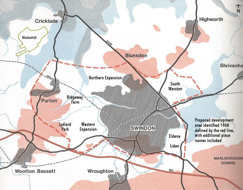
Once Swindon had been identified for major expansion, planners from Swindon, Wiltshire County and Greater London Council produced a report published in 1968 setting out how and where such growth might be achieved. Known as the Silver Book, because of its shiny cover, 'Swindon - A Study for Further Expansion' outlined a vast new urban area (described below).
But the ambitions of the strategic planners were not to be achieved in the short term. The current boundary of West Swindon, much of which was built in Wiltshire and transferred to Swindon, was regarded as the limit of urban expansion for most of the 1970s, 80s and 90s.
Most of the growth during the last quarter of the 20th Century has taken place within the borough boundaries to north and east, but the pressure to grow westwards again has been mounting. Ridgeway Farm and Mouldon View, on Swindon's boundary in Wiltshire, started in 2011. In the next phase of strategic land planning from 2026, it is questionable whether Swindon can continue to be contained.
• The Silver Book proposed the town’s boundaries expanding outwards to the dashed red line. It takes in what we know as West Swindon, development at Liden and Eldene in the east within the town, and also North Swindon.
It also identifies areas which have been fought over at planning enquiries more recently - Tadpole Farm, Ridgeway Farm, Mouldon View and land between Blunsdon and South Marston - all of which are now in the process of being built upon.
Also within the red line boundary is Purton and Wootton Bassett. Pry Farm between Purton and North Swindon was considered for development in 2008/9, but put on hold. It will probably feature in the next Wiltshire Council Core Strategy proposals due in 2026.
Interestingly, the development of 4,000 homes at Wichelstowe, the 8,000 proposed for the Eastern Villages, and the Badbury Park development close to Coate Water, did not feature in the Silver Book plan.